"No no" cried Puffy Head. "Well, I think I will take you to my police office. I will not put you in jail if you sign a agreement that this will not happen again." Arrow said sternly. " Welll iiff I doo not have too ggoo to jail I will go." said puffy Head in a very scared voice. So Puffy Head went to Arrow's office to sign the agreement. Meanwhile Felix had seen Puffy Head go away. Hmmm Felix said to himself, If he is gone maybe I can take his grasshopper soup!
To see the first part of the story click HERE
Sunday, June 28, 2009
Thursday, June 25, 2009
Lightning!
Pictures of lightning!

 In this picture you can see the setting sun and a lightning strike!

It has been VERY hot lately... Well I forgot what else I was go to write...

 In this picture you can see the setting sun and a lightning strike!
It has been VERY hot lately... Well I forgot what else I was go to write...
Good Melting! That is, if it's as hot as it is here.
Sunday, June 21, 2009


Saturday, June 20, 2009
Whats this?
I took a picture of something....Here is a picture of it.
Well, what do you guess it is?................Hmmmmmm
Good Buy! ;)
Well, what do you guess it is?................Hmmmmmm
Good Buy! ;)
Wednesday, June 17, 2009
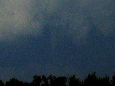
Tornadic thunderstorm!
Here is a live lapse video of the beginnings of a tornadic thunderstorm. About 15-20 or less minutes after I took this video a tornado was reported with this storm.
Good afternoon!
Good afternoon!
Monday, June 15, 2009
Copy and paste
Copy this and paste into Google(Jenny): The Extreme Weather Blog. Elon and Ezra write on it. and Jenny writes comments.
;)
;)
Poll results
Well, the poll has ended so I'll post the results and where they are too.
Deadhorse, Alaska wins with three votes!
Three tied for second place:
Bishkek, Kyrgyzstan with two votes.
Ljubljana, Slovenia with two votes.
Puerto Natales, Chile with two votes.
Mbala, Zambia comes in third place with one vote.
Qom, Iran is the loser with zero votes.
And that is all from me.
----Ezra
Tornado!
Ok, here is the picture of the tornado. Sorry it is a bad picture....because it was dark and it was long ways away.
 It was probably was 10 miles away. Of course it was a small tornado...EF-0.
Good bye!
 It was probably was 10 miles away. Of course it was a small tornado...EF-0.
Good bye!
Wednesday, June 10, 2009
Wow!
This afternoon there was a tornado about 6-8 miles away from here! And we saw it! Wow our first tornado!( Well I think it was a tornado)
Elon
P.S. More information and a picture to come!
Elon
P.S. More information and a picture to come!
Tuesday, June 9, 2009
SEVERE THUNDERSTORMS!
Some Severe thunderstorms are possible today( June 9th). The SPC has a slight risk for severe thunderstorms for today.
Here is the NATIONAL WEATHER SERVICE IN SPRINGFIELD MO's HAZARDOUS WEATHER OUTLOOK:
THIS HAZARDOUS WEATHER OUTLOOK IS FOR PORTIONS OF THE MISSOURIOZARKS AND EXTREME SOUTHEAST KANSAS..
DAY ONE...TODAY AND TONIGHT.ONGOING SCATTERED THUNDERSTORMS WILL BE POSSIBLE OVER SOUTHCENTRAL MISSOURI OVERNIGHT. UP TO ONE INCH HAIL AND WIND GUSTS OF40 TO 50 MPH WILL BE POSSIBLE WITH STRONGER STORMS ALONG THEARKANSAS BORDER EAST OF THE GAINESVILLE AREA.
SEVERE THUNDERSTORMS WILL BE POSSIBLE OVER THE OUTLOOK AREA THIS AFTERNOON AND TONIGHT.A FRONT THAT EXTENDS FROM OKLAHOMA INTO NORTHERN ARKANSAS EARLYTHIS MORNING IS EXPECTED TO GRADUALLY LIFT NORTH AS A WARM FRONTTODAY. LIFT UP AND OVER THIS FRONTAL BOUNDARY WILL RESULT IN THEDEVELOPMENT OF WIDELY SCATTERED THUNDERSTORMS THIS MORNING. SOMESTORMS WILL INITIALLY BE CAPABLE OF ONE INCH HAIL.INSTABILITY IS EXPECTED TO INCREASE WITH SURFACE HEATING THISAFTERNOON.
THUNDERSTORMS ARE EXPECTED TO INCREASE IN COVERAGE WITHBETTER CHANCES FOR STRONG TO SEVERE THUNDERSTORMS. HAIL UP TO THESIZE OF GOLF BALLS AND DAMAGING THUNDERSTORM WINDS WILL BEPOSSIBLE. STRONG VERTICAL WIND SHEAR PROFILES...ESPECIALLY OVER WESTERNPORTIONS OF MISSOURI AND SOUTHEAST KANSAS...WILL ALSO LEAD TO ASOMEWHAT HEIGHTENED RISK FOR TORNADOES AS WELL.
A CAP IS EXPECTED TO GRADUALLY SPREAD NORTHEAST INTO FAR SOUTHWESTMISSOURI AND SOUTHEAST KANSAS LATE THIS AFTERNOON AND EARLY THISEVENING BEHIND THE WARM FRONT. THUNDERSTORM ACTIVITY WILLDIMINISH AS THE CAP SPREADS INTO THOSE AREAS...BUT THUNDERSTORMSWILL CONTINUE TO BE POSSIBLE NORTH OF THE WARM FRONT OVER PARTS OFSOUTHEAST KANSAS INTO WEST CENTRAL AND CENTRAL MISSOURI THROUGHTHE EVENING AND POSSIBLY INTO THE OVERNIGHT HOURS. ONE INCH HAILAND DAMAGING THUNDERSTORM WINDS WILL BE POSSIBLE...ESPECIALLY IFTHE STORMS CAN ORGANIZE INTO A STORM COMPLEX OVERNIGHT.
So hail to the size of golf balls....thunderstorm wind gusts up to 70mph and isolated tornadoes are all possible For us.
Monday, June 8, 2009
New poll!
There's a new poll to the left. Please vote! I will post the winner, as well as where they are, sometime after the poll ends on June 15.
---Ezra
---Ezra
What do you think?
Would you like it if I would post posts about the latest weather?
For example: Monday June 35th 2010 Today light snow showers in the morning. total snow accumulation about 1.5 inches. Snow stopped around noon. Then gradually clearing off. by evening it was totally clear. The high for today was 81...and the low was 65.
what do you think?
For example: Monday June 35th 2010 Today light snow showers in the morning. total snow accumulation about 1.5 inches. Snow stopped around noon. Then gradually clearing off. by evening it was totally clear. The high for today was 81...and the low was 65.
what do you think?
Thursday, June 4, 2009
Cute!
See! He jumped on the camera. I guess that is why they call them jumping spiders.
Good late afternoon!
Elon
Wednesday, June 3, 2009
New Contributor!
There is a new contributor on here! Guess who it is?
It is Buzz Grins! So now Buzz can write stuff on here. Only one thing.... I might be hard to get him to post something. So why don't you tell him to write some thing ok?
Well I don't know what else to write. Except that James(Jamz or Jamez) so far is the highest voted on the poll(about who is writing the Anonymous comments).
Would you like it if I posted what we have been doing lately?
Good night!
Elon
Monday, June 1, 2009
Poll
There is a poll on right side and down a bit. . Vote for who you think is writing the Anonymous comments.
Subscribe to:
Posts (Atom)